ČACHROV | Mikroregion Šumava Západ
Menu
Menu
Levý sloupec - Čachrov
Contact
Ing. Jaroslav Tachovský
Chairman of the Coordinating Council
Modrava 63
341 92 Kašperské Hory
E-mail: mikroregion@sumavanet.cz
Tel. : +420 602 680 178
Čachrov
Altitude: 716 above sea level
Origins: first mentioned in 1352
Number of inhabitants: 568
Administrative area in hectares: 8818 ha
Settlements falling into the administrative area: Bradné, Březí, Čachrov, Dobřemilice, Chřepice, Chvalšovice, Javorná, Jesení, Kunkovice, Onen Svět, Předvojovice, Svinná, Zahrádka.

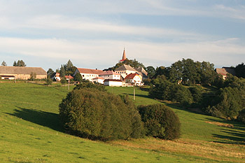
In 1380 – 1390 Vilém of Čachrov built an extensive fortification above the left bank of the Ostružná stream. A massive tower with Gothic windows and portals has been preserved till the present times. The fortification was entered via a portal, which has not survived, on the first floor level and then a narrow passage would lead one to the living quarters. The building is being reconstructed and it will be used for cultural events organised by the village.
Another point of interest is the Gothic Church of St Wenceslas dating from 1360. It was reconstructed in the 18th century. In 1804 a tower was built onto the Church.
In terms of industry there were graphite mines in the area, Kordík lime works and a brewery. In 1901 one of the first cooperative power plants in the country was built in the village following the design made by František Křižík. In 1904 Čachrov became a market town.

Cyclists might like to explore the circular cycling route no. 2037 which is 13 km long and which is connected with a network of other cycling routes. In winter there are cross country skiing tracks available and ski lifts which are only about 800 m from the village. There are several pensions in the village offering food throughout the day.


